| UWAGA |
|---|
Większość artykułów w portalu to nasze własne teksty z kluczowych dziedzin związanych z naszą misją. Spora część materiałów pochodzi też z polskiej wersji Wikipedii, gdzie były odrzucone ze względu na politykę redaktorów (przeczytaj o krytyce Wikipedii). Są też i takie, które zostały przeniesione na nasze strony, gdyż stanowią istotne uzupełnienie merytorycznej treści naszego serwisu. Wszystkie artykuły podlegają edycji przez naszych Użytkowników, dlatego ich wersje mogą się różnić od prezentowanych na innych witrynach. |
Plik:Blue Marble Western Hemisphere.jpg

Rozmiar pierwotny (3718 × 3718 pikseli, rozmiar pliku: 2,65 MB, typ MIME: image/jpeg)
Opis
| Opis |
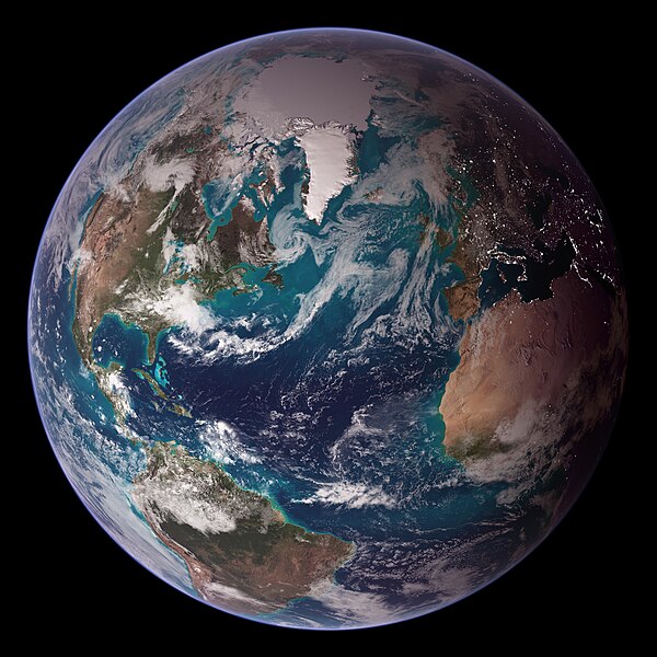
English: RELEASE DATE: OCTOBER 9, 2007
Credit: NASA/Goddard Space Flight Center/Reto Stöckli A day’s clouds. The shape and texture of the land. The living ocean. City lights as a beacon of human presence across the globe. This amazingly beautiful view of Earth from space is a fusion of science and art, a showcase for the remote-sensing technology that makes such views possible, and a testament to the passion and creativity of the scientists who devote their careers to understanding how land, ocean, and atmosphere—even life itself—interact to generate Earth’s unique (as far as we know!) life-sustaining environment. Drawing on data from multiple satellite missions (not all collected at the same time), a team of NASA scientists and graphic artists created layers of global data for everything from the land surface, to polar sea ice, to the light reflected by the chlorophyll in the billions of microscopic plants that grow in the ocean. They wrapped these layers around a globe, set it against a black background, and simulated the hazy edge of the Earth’s atmosphere (the limb) that appears in astronaut photography of the Earth. The land surface layer is based on photo-like surface reflectance observations (reflected sunlight) measured by the Moderate Resolution Imaging Spectroradiometer (MODIS) on NASA’s Terra satellite in July 2004. The sea ice layer near the poles comes from Terra MODIS observations of daytime sea ice observed between August 28 and September 6, 2001. The ocean layer is a composite. In shallow water areas, the layer shows surface reflectances observed by Terra MODIS in July 2004. In the open ocean, the photo-like layer is overlaid with observations of the average ocean chlorophyll content for 2004. NASA’s Aqua MODIS collected the chlorophyll data. The cloud layer shows a single-day snapshot of clouds observed by Terra MODIS across the planet on July 29, 2001. City lights on Earth’s night side are visualized from data collected by the Defense Meteorological Satellite Program mission between 1994–1995. The topography layer is based on radar data collected by the Space Shuttle Endeavour during an 11-day mission in February of 2000. Topography over Antarctica comes from the Radarsat Antarctic Mapping Project, version 2. Most of the data layers in this visualization are available as monthly composites as part of NASA’s Blue Marble Next Generation image collection. The images in the collection appear in cylindrical projection (rectangular maps), and they are available at 500-meter resolution. The large images provided above are the full-size versions of these globes. In their hope that these images will inspire people to appreciate the beauty of our home planet and to learn about the Earth system, the developers of these images encourage readers to re-use and re-publish the images freely. NASA images by Reto Stöckli, based on data from NASA and NOAA. To learn the history of the Blue Marble go here: earthobservatory.nasa.gov/Features/BlueMarble/BlueMarble_... To learn more about the Blue Marble go here: earthobservatory.nasa.gov/IOTD/view.php?id=8108 NASA Goddard Space Flight Center is home to the nation's largest organization of combined scientists, engineers and technologists that build spacecraft, instruments and new technology to study the Earth, the sun, our solar system, and the universe. Follow us on Twitter Join us on FacebookEspañol: Mosaico de fotografías del hemisferio occidental, proyectadas sobre una esfera y procesadas.
Polski: Mozaika zdjęć półkuli zachodniej, zrzutowana na sferę i poddana obróbce.
Русский: Изображение, составленное из мозаики фотографий Западного полушария Земли из космоса
Українська: Мозаїка фотографій Західної півкулі Землі, спроектованих на сферу та оброблених. |
| Data | |
| Źródło | Earth Observatory: Twin Blue Marbles |
| Autor | NASA images by Reto Stöckli, based on data from NASA and NOAA. Instrument: Terra - MODIS |
Wyróżnienia
|
Ta grafika została wybrana grafiką dnia 30 listopada 2023 roku. Została opisana następująco: Polski: Mozaika zdjęć półkuli zachodniej, zrzutowana na sferę i poddana obróbce. Inne języki:
Čeština: Modrá skleněnka foto z roku 2007. Deutsch: Die westliche Hemisphäre der Erde, zusammengesetzt aus unterschiedlichen Einzelaufnahmen. English: The Blue Marble (2007) Español: Mosaico de fotografías del hemisferio occidental, proyectadas sobre una esfera y procesadas. Esperanto: la Blua Globeto Français : L'hémisphère ouest de la Terre vu depuis l'espace, avec le continent américain à gauche et l'Europe et l'Afrique à droite. Photo recréée par la NASA en fusionnant plusieurs images prises par différentes missions spatiales. Magyar: A Föld nyugati féltekéjéről készült fényképek mozaikja gömbre vetítve és feldolgozva Nederlands: Blue Marble (2007) Polski: Mozaika zdjęć półkuli zachodniej, zrzutowana na sferę i poddana obróbce. Português: Mosaico de fotografias do hemisfério ocidental, projetadas em uma esfera e processadas. Македонски: Западната полутопка на Земјата. Русский: Изображение, составленное из мозаики фотографий Западного полушария Земли из космоса. Українська: Мозаїка фотографій Західної півкулі Землі, спроектованих на сферу та оброблених. 中文: 《藍色彈珠》,拍摄于2007年 |
Licencja
| Ten plik jest w domenie publicznej ponieważ został stworzony przez NASA. Polityka praw autorskich NASA stwierdza, że „materiały NASA nie są chronione prawami autorskimi, chyba że zapisano inaczej”. (NASA copyright policy lub JPL Image Use Policy). | ||
 |
Uwaga:
|
Historia pliku
Kliknij na datę/czas, aby zobaczyć, jak plik wyglądał w tym czasie.
| Data i czas | Miniatura | Wymiary | Użytkownik | Opis | |
|---|---|---|---|---|---|
| aktualny | 13:59, 5 mar 2013 | | 3718 × 3718 (2,65 MB) | Szczureq | User created page with UploadWizard |
Lokalne wykorzystanie pliku
Żadna strona nie korzysta z tego pliku.